It’s been a good while since I’ve done a Learning to Fly post. Since the last time, I’ve completed my first biennial flight review, which is a mandatory mini-checkride done every two years with a flight instructor, that’s designed to verify that a pilot has properly maintained both their flying skills and regulatory knowledge.
I’ve been doing a ton of local flying around Puget Sound, plus a few flights over the mountains to central Washington state, all via rented aircraft from Galvin Flying.
Because of the Pacific Northwest’s consistently lousy winter weather, with very low clouds, rain, and low visibility, it had been a couple months since my last flight. So I booked some time with a trusted CFI and got lucky with a nice weather window, and off we went to do some practice.
I honestly miss the structure of flight training. You could expect to be constantly challenged, and asked to randomly perform flight maneuvers or emergency procedures. There are still plenty of challenges when flying on your own, but you soon settle into comfortable routines.
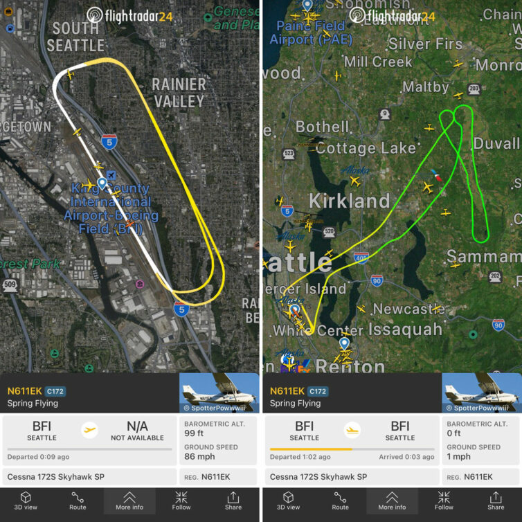
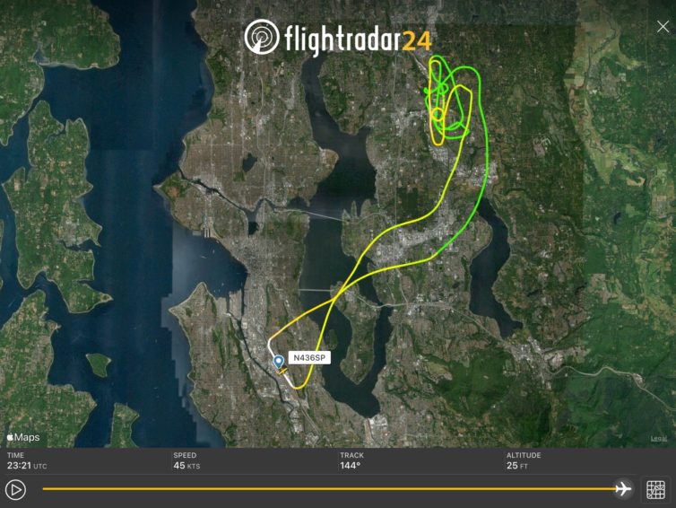
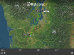
Our flight track from Flightradar24 – the first one is our pattern work, the second is the entire flight
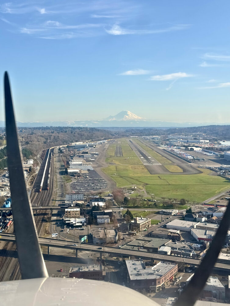
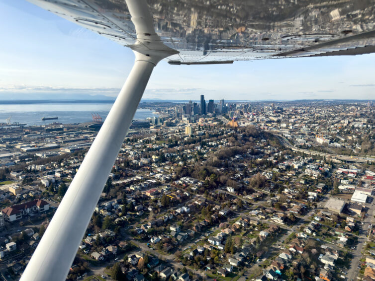
Our training flight first consisted of three laps around the traffic pattern at Seattle’s Boeing Field doing touch-and-go landings, then we exited the pattern and flew to one of our local practice areas, the one we refer to as northeast practice, as it lies to the northeast of BFI. We also have west practice, which is across Puget Sound and east of the Bremerton airport, and southeast practice, which is, perhaps unsurprisingly, southeast of BFI and east of Auburn airport.
A lot of my own flying has been to the southwest over to Tacoma Narrows Airport, or northwest along the Olympic Peninsula to Jefferson County Airport in Port Townsend, so we went northeast for something of a change, plus the transit time is the shortest of the three training areas.
Traffic is always a concern when flying in congested airspace; going out on the first good afternoon following a spell of bad weather always means there is plenty of traffic to keep an eye on
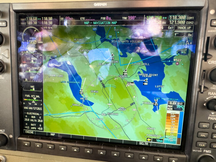
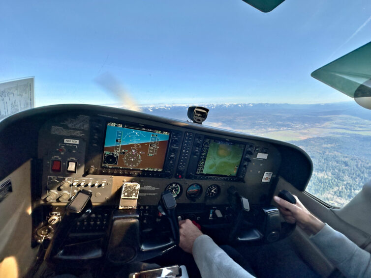
The Cessna 172 we flew that day was equipped with a Garmin G1000 instrumentation and navigation system, which includes traffic. The arrows on the screen above represent aircraft in the area as we were leaving the practice area and descending to stay well beneath SEA’s overhead Bravo airspace when we were returning to BFI. The extended line from each arrow shows direction of travel, and the numbers indicate the altitude above or below your own; super handy info to augment what you’re seeing out the windshield.
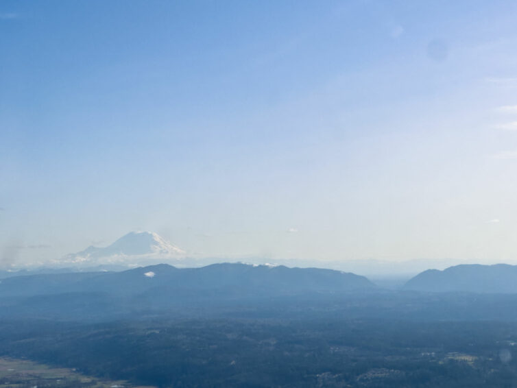
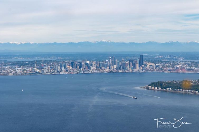
Sitting at the hold-short line, waiting for takeoff clearance. Photo by Adam KephartDowntown Seattle and Puget Sound. Photo by Adam KephartMount Rainier makes an excellent reference point for doing maneuvers over the northeast practice area
There was nothing crazy or groundbreaking about the flight. We did some touch-and-go landings, then went out to the practice area and did a couple of stalls (one power-off approach to landing stall, and one power-on departure stall), and then headed back.
Adam the CFI took the controls so I could grab a few photos
It’s focused practice flights such as these that keeps you safe as a pilot, and keeps your basic proficiency levels up to standard. I’ll go out again with Adam this spring to do some simulated emergencies to keep those skills sharp, too.
And I’ll leave you with one more photo of one of my favorite views ever. More soon — summer is coming.
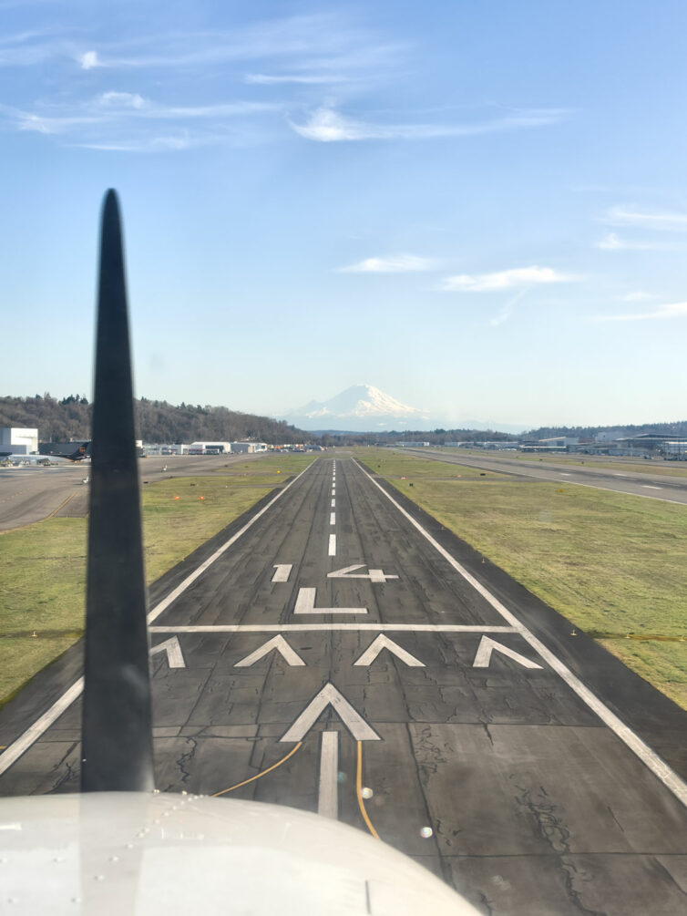
Just about to touch down on 14L at the end of the flight. Photo by Adam Kephart.
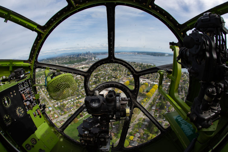
Looking out the nose of a B-29 over Seattle – Photo: Jeremy Dwyer-Lindgren
Typically we cover airlines and airliners here at AirlineReporter, but occasionally an opportunity in the non-airline[r] worlds pops up that we just can’t pass on.
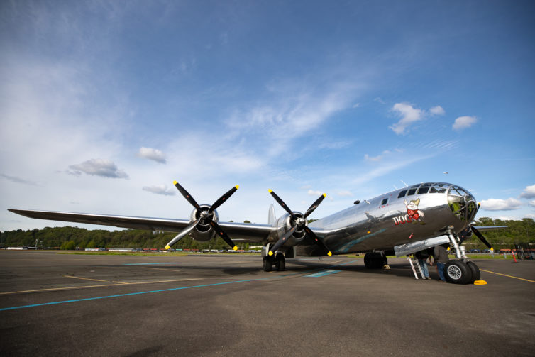
So when the Museum of Flight here at our Seattle HQ announced that Doc, one of only two airworthy Boeing B-29 bombers, was planning to visit in mid-May, we jumped at the chance to see her up close. Even better, we got to take a short ride around Seattle.
The airplane arrived earlier this week (May 17). Its Star Wars-esque nose, four engines, and incredibly shiny fuselage made it easy to spot on the horizon. The pilots eased the bird onto the runway and taxied down to the Museum of Flight ramp as a crowd of onlookers gathered to watch.
While the B-29 was originally produced in Seattle, Doc is not a native Pacific Northwesterner. It was one of 1,644 B-29s built at Boeing’s Wichita plant, in Kansas, and rolled off the line in March of 1945. It never saw combat, and went on serve in radar calibration and target-towing until it was decommissioned in 1956.
Doc, one of two airworthy Boeing B-29 bombers left in the world, rests after a media flight at Boeing Field in Seattle on May 17, 2022
It continued its service to the United States Air Force even after retirement, but instead of towing targets, it became one. The airplane spent decades soaking in the desert sun, along with the occasional bomb or bullet, on an Air Force bombing range near China Lake, California before being discovered in 1987. Restoration didn’t begin for another decade, in 1998, following a considerable amount of paperwork to pry the plane loose from the US government. Eighteen years and over 450,000 volunteer hours after that, the restoration was complete, and Doc once again took flight in 2016.
Its Seattle visit is the first for Doc, and the first B-29 visit to the area in almost eight years.
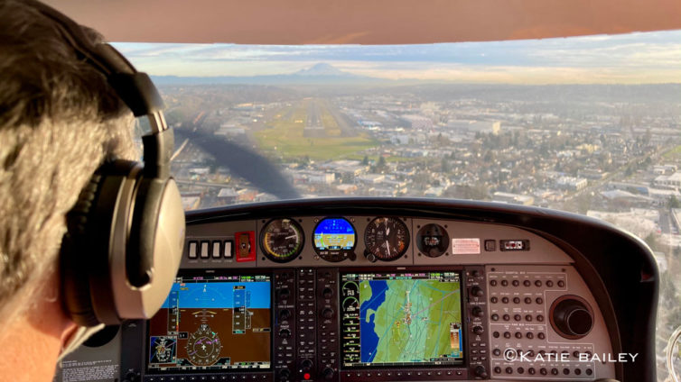
On final for runway 14R at BFI in a Diamond DA-40 – this wasn’t from our mountain-flying day, but it’s too pretty of a photo to leave out of the article
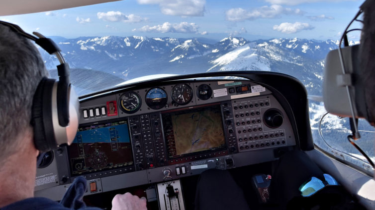
The lousy Pacific Northwest early spring weather notwithstanding, I’ve made good progress towards learning both the Garmin G1000 instrumentation and the Diamond DA-40 aircraft. We recently got a decent break in the weather that allowed a flight from Seattle across the Cascade Mountains to Ellensburg for some basic mountain flying training.
Cruising westbound at 6,500′ over Snoqualmie Pass was an amazing experience – Photo: Katie Bailey
I’ve got about 10 hours in the DA-40 now, all but one of them with Carl, my ever-patient CFI. I finally felt comfortable enough with the plane to take it out on my own last week, even though Carl had deemed me ready to do that about five flight hours previously. I just wanted a bit more time with the plane, as it’s quite a bit different than the Cessna 172, especially in that it’s a lot faster and a bit fussier when it comes to controls, and it’s got a constant-speed propeller (also sometimes referred to as a variable-pitch propeller) that needs tending to via a dedicated control lever.
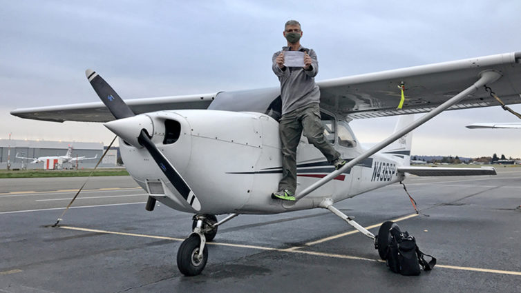
After a year and a half of concerted effort, I’ve finally completed my initial training and earned my private pilot certificate in early November. It’s a great feeling!
For those who’ve been following along on my adventures at Galvin Flying, it’s been a long process of successes and setbacks, many of which were weather related because I live in the Pacific Northwest, where the local joke says that it only rains once a year it starts raining in late October and stops raining on July 5 (it always seems to rain on July 4).
In case you ever wondered what the track of a checkride looks like, here you go. Screen capture courtesy FlightRadar24
Anyway, I did several mock checkrides in the weeks leading up to the actual FAA one, and had to complete Galvin’s end-of-course checkride before that. The end-of-course checks are designed to be more difficult than the actual checkride to ensure that pilot candidates are as prepared as possible.
The FAA examiner, also known as a designated pilot examiner or DPE, selects from a long list of information and flight maneuvers for the actual checkride known as the Airman Certification Standards. The check airman who oversees the end-of-course checks runs through the entire list to be sure you’re ready.
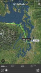
Returning to Boeing Field after my first solo cross-country flight to Port Angeles, Wash. That’s the Seattle skyline in the foreground, Bellevue in the middle-right, and the Cascade Mountains in the distance
So, it’s been a while since I’ve written an update, but that doesn’t mean I’ve not been making progress.
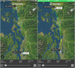
Since the last installment, I’ve done my three cross-country solo flights – they’re a requirement for the PPL, and consist of several solo flights away from one’s home airport. Cross-country meaning, you know, crossing the countryside and not a transcontinental flight in a small plane, which would take a couple days at best.
Requirements for the cross-country flights are that the each one has to include one leg of at least 50 nautical miles and a full-stop landing. For the long cross-county, the flight has to be a minimum of 150nm and include one leg of at least 50nm and full-stop landings at three airports, including returning to the point of origin.
My first cross-country flight was from Boeing Field to Fairchild International Airport in Port Angeles, Wash. -FlightRadar24 screen grab
The second cross-country flight was from Boeing Field to Chehalis, Wash. -FlightRadar24 screen grab
The third (long) cross-country flight was from Boeing Field to Bellingham, Wash., with a stop at Paine Field in Everett on the way home. -FlightRadar24 screen grab
For my flights, the first one was from Boeing Field (BFI) up to Port Angeles on the Olympic Peninsula. It was a spectacular day – completely free of turbulence, hardly any other air traffic, and clear as the proverbial bell.
The second one was the following week, from BFI to Chehalis, Washington, a bit south of Olympia. It was far more normal, with usual amounts of air traffic and slightly bumpy/windy conditions.