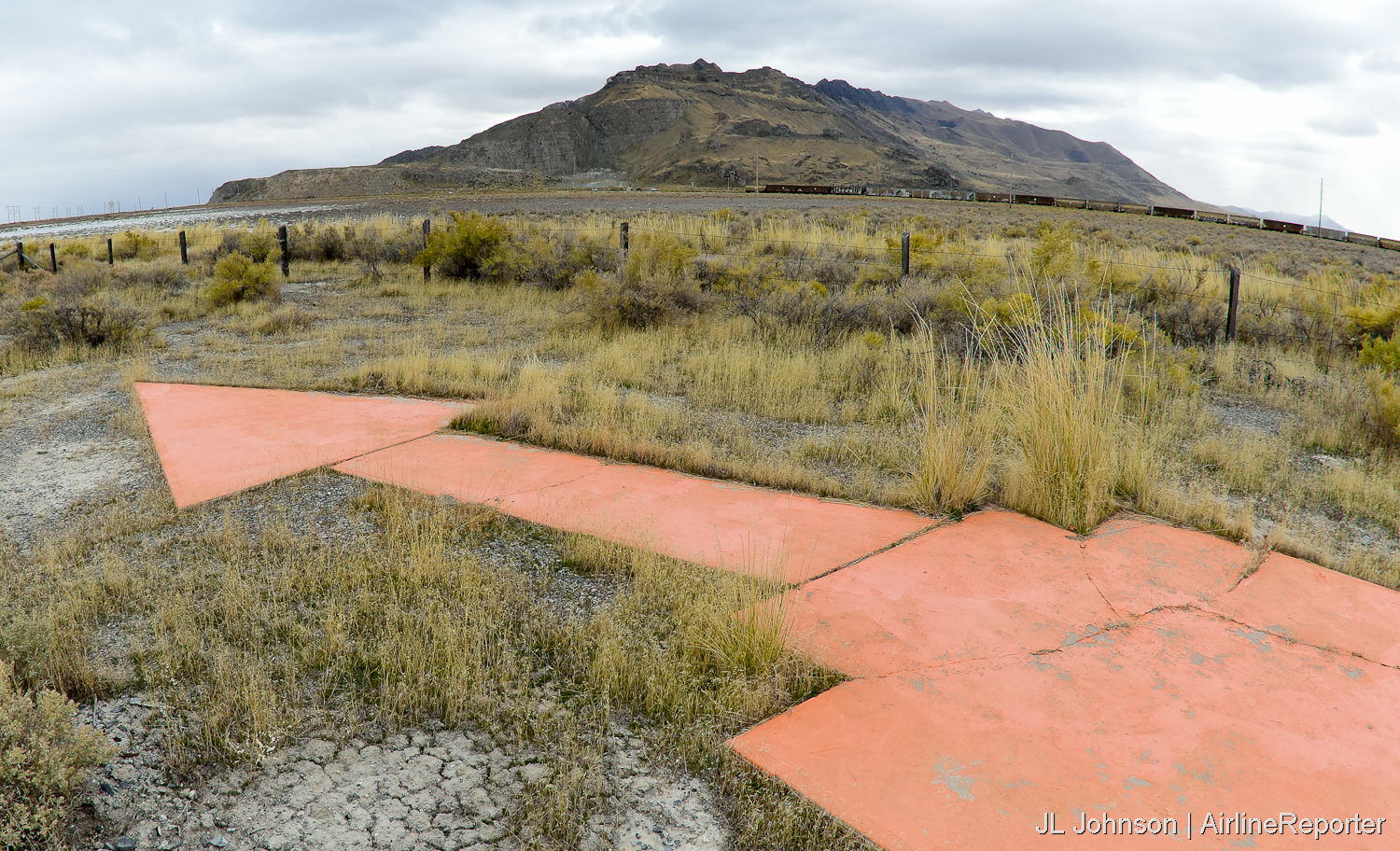
Seen in 2019 – an air mail arrow outside Salt Lake City, Utah points to SLC on the San Francisco-Salt Lake route
We aren’t ready to fly. Which is a bummer because travel is a large part of our identity. What are sidelined AvGeeks to do to remain connected to our passion? We are all coping with this disaster
A 1920s advertisement bringing awareness to the TAS. – Image: Public Domain
in different ways. Looking to an aspirationally brighter future (and planning future travel) is certainly one method that holds promise. For my [formerly] frequently-traveled household we have been deep in research and planning for most of the year. As a result, our impossibly long #AvGeekToDoList has grown a great deal since our voluntary pandemic-grounding. One item of low-hanging socially-distanced fruit on our list is getting out and visiting more air mail arrows.
I have long been fascinated with the infancy of U.S. aviation. Keen AirlineReporter readers and AvHistorians alike will know that the modern aviation industry is what it is because of air mail. Indeed, all of the domestic legacies – except Delta – were formed or became successful because of income from air mail. These earliest routes were flown mostly during the day. In the evenings, mail would continue to travel, albeit via train. To further increase the speed of airmail it was determined night flying would be required. Thankfully congress stepped in to fund a vast array of large concrete arrows and beacons which formed the lighted Transcontinental Airway System (TAS.) At its peak the TAS had one concrete arrow roughly every 10 miles along the various routes. The TAS and its air mail arrows provided the infrastructure for the air mail boom which, in time, led to normalization of passenger service.
BONUS: How Delta got their non-airmail start
Join us for a discussion on how you can plan your own trip to visit these nearly forgotten 1920s-era relics of aviation’s past.
Finding your own air mail arrows and beacons:
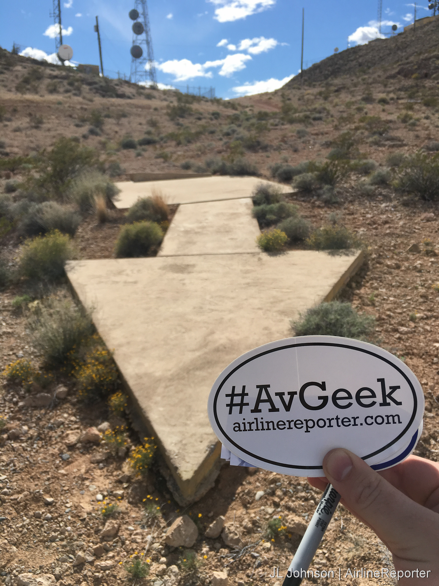
2016 – An air mail arrow in Clark County, Nevada points to Salt Lake City on the Los Angeles-Salt Lake route
Most of the TAS sites no longer exist. After only a few decades of use they simply were no longer needed thanks to the advancement of technology. By the time the U.S. entered World War II, it was clear the giant concrete arrows pointing to major cities were an issue of national security and many were intentionally destroyed. A few dozen air mail arrows and/or their related structures remain sprinkled about the continental U.S. Surprisingly, the few I have visited personally (most in the Southwest) remain in decent condition.
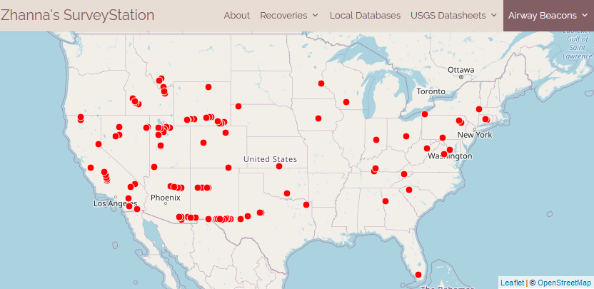
Map with likely TAS locations. Image: – Zhanna’s SurveyStation
Of the remaining sites, a good number remain on public land an hour or two from major cities or airports. Some are on-site at small airports which are generally happy to invite visitors on pre-arranged visits, and at least one has transformed to the Aviation Heritage Museum in New Mexico. Air mail arrows are found on private property (get permission), right off of major interstates, at the top of mountains and in the middle of deserts. Trips to these sites requires a lot of research and planning. For someone like me, that’s where the fun begins because with effort comes rarity of experience.
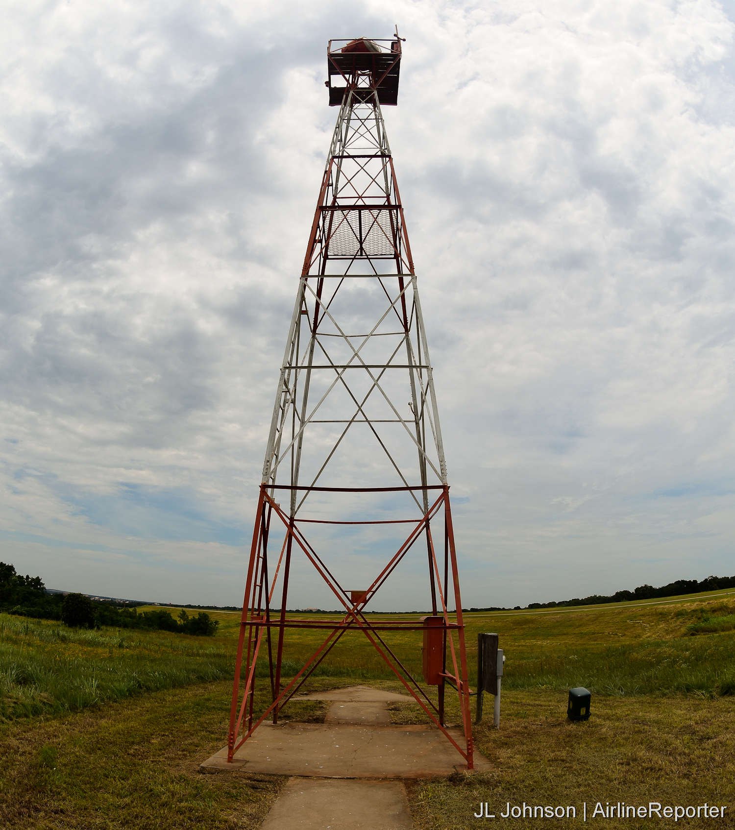
A rare air mail arrow and beacon combo seen at GOK- Guthrie Edmond Regional Airport, Oklahoma in 2016
There are many sites that will aid you on your journey. I suggest looking at a bare minimum the following:
- DreamSmithPhotos– Perhaps the most comprehensive site which has been added to for many years. Go here for lists of sites by state including historical documents which provide background on many of the sites.
- Zhanna’s SurveyStation– More information on locations, in some cases with more recent reports on conditions.
- Wyoming PBS- Cowboys of the Sky- A public media produced 27 minute video discussing air mail and other early aviation topics with some emphasis on Wyoming.
Conclusion:
There is no better time than now to start researching and planning your own excursion to visit one or more of these sites. Be safe and respect private property, but get out and visit these unique links to aviation’s past. For without these arrows, the industry as we know it today would be drastically different.
Have you been to any of these sites, or have we made the case for you to do so? Let’s continue the conversation in the comments below. And when you do make it to one of these sites, let us know with a Tweet or email.
Comments are closed here.
Very cool article! Thanks!
Our HAM radio club has a 2m repeater site that is built on top of the arrow on Beacon Hill between Laramie and Cheyenne Wyoming. It was built in the mid 60s just after the Forest Service removed the beacon tower. The concrete block hut for the repeater sits on the concrete pad that was under the tower. The arrow is still in pretty good shape and we are hoping to working with the Forest Service on a plan to prevent further damage to it.
Brad, that sounds awesome. Be sure to check out that great documentary by WyomingPBS. I also here they are trying to restore the intermediate landing field at Medicine Bow. We are planning an I-80 trip for next year.
Looking forward to it.
JLJ / AirlineReporter
JLJ
I have seen the Wyo PBS doc about the air mail system. Here is a drone picture shot about a month ago on a cold windy say at the site as the HAMs were working on the tower we installed. You can see the arrow point under some of the snow, the shaft is covered by loose gravel, the hut sits on the base where the tower went up.
https://wyosullivan.smugmug.com/Pilot-Hill-Repeater/n-bsGRzp/i-G2mRHbX/A
Very cool!
Hii Great Articles.
Visit : https://deltaflightscheap.com/
I really appreciate this wonderful post that you have provided for us. I feel strongly that love and read more on this topic. I have spent a lot of my spare time reading your content. Thank you a lot.
An air mail beacon site located East of Quartzite, Arizona is in danger of being looted. The site still has the tower, the rotating beacon, and one of the on-course lights [the other on-course light is missing]. A very irresponsible YouTube content producer published a video about the site which makes its location obvious. Something needs to be done to get the rotating beacon and the on-course light into a museum. If anyone has a suggestion, please let me know.
Your map seems to have completely missed the Airmail Beacons of the Columbia River Gorge. I’ve been researching them because my grandfather was the mechanician in charge of their maintenance from 1930 until his death in 1944. The route ran from Portland, Oregon to Pasco, Washington and had beacons roughly every 15 miles. One of the last remaining beacons (from Cascade Locks) is currently on display at the Western Antique Aeroplane and Automobile Museum (WAAAM) in Hood River, Oregon. I have memories as a small girl in the 1960s of seeing the one just east of Mosier, Oregon.
The map may be correct, in doing some reading on this subject, it appears the later addition of a special lighting type in the Columbia Gorge was required due to low cloud and fog. These were intended to allow very low altitude flying down the gorge, with green lights on the North side and red on the South side. These sound very different from those installed earlier across the country and may have been a local addition. The original CAM-5 air route went to Pasco in 1926 and didn’t connect to Portland. It appears these routes changed over time, Portland was added, and after 1940 Pendleton replaced Pasco. Very interesting history, including the intermediate airfields along the way.
Was doing some additional reading of the CAM32 route from Portland to Spokane, which was in two segments, Portland to Pasco and Pasco to Spokane. In reading the log of construction activity, it clearly states the construction of the airfields, beacons and special lighting along the Columbia Gorge was started in 1930, as were those to Spokane. The Pasco to Spokane improvements were completed first, and the more challenging Gorge improvements took almost a year longer. By that time in 1931 it looks like Varney Airline that had initiated the CAM5 route service to Pasco had merged with others to become what became United Airlines. It appears CAM32 was merged with CAM5 at some point, You are correct on the facts, there were Airmail Route Beacons and likely arrows on the Columbia Gorge as well as the special lighting unique to the gorge. Interesting history!
Susan, Your memory is correct the Lyle Beacon was just East of Mosier in Wasco County, and was intact through the 1959 according to notations on the site data.